342,249 buildings · real heights
Every building in Hong Kong, down to your window.
Zoning, height limits, land lots, school nets and government records on one map — and for any flat, pick the floor and the facing to see the hours of sun it really gets. In 繁中, 简中 and English.
Free — the whole map, no account. No listings, no agent spam. Government open data, with attribution.
Sunlight
Stand at the window before you buy.
Pick a floor and a facing. The map shows when the sun reaches that window, when it has gone behind the wall — and which building takes the rest of the day.


View
Three ways to look at one window.
The same measurement, seen from three places. Switch with one tap — the floor and the facing stay where you put them.
Try it here — this is the map itself, open on K11 MUSEA in Tsim Sha Tsui with the sun tool on. Click a window, then switch between the three views.
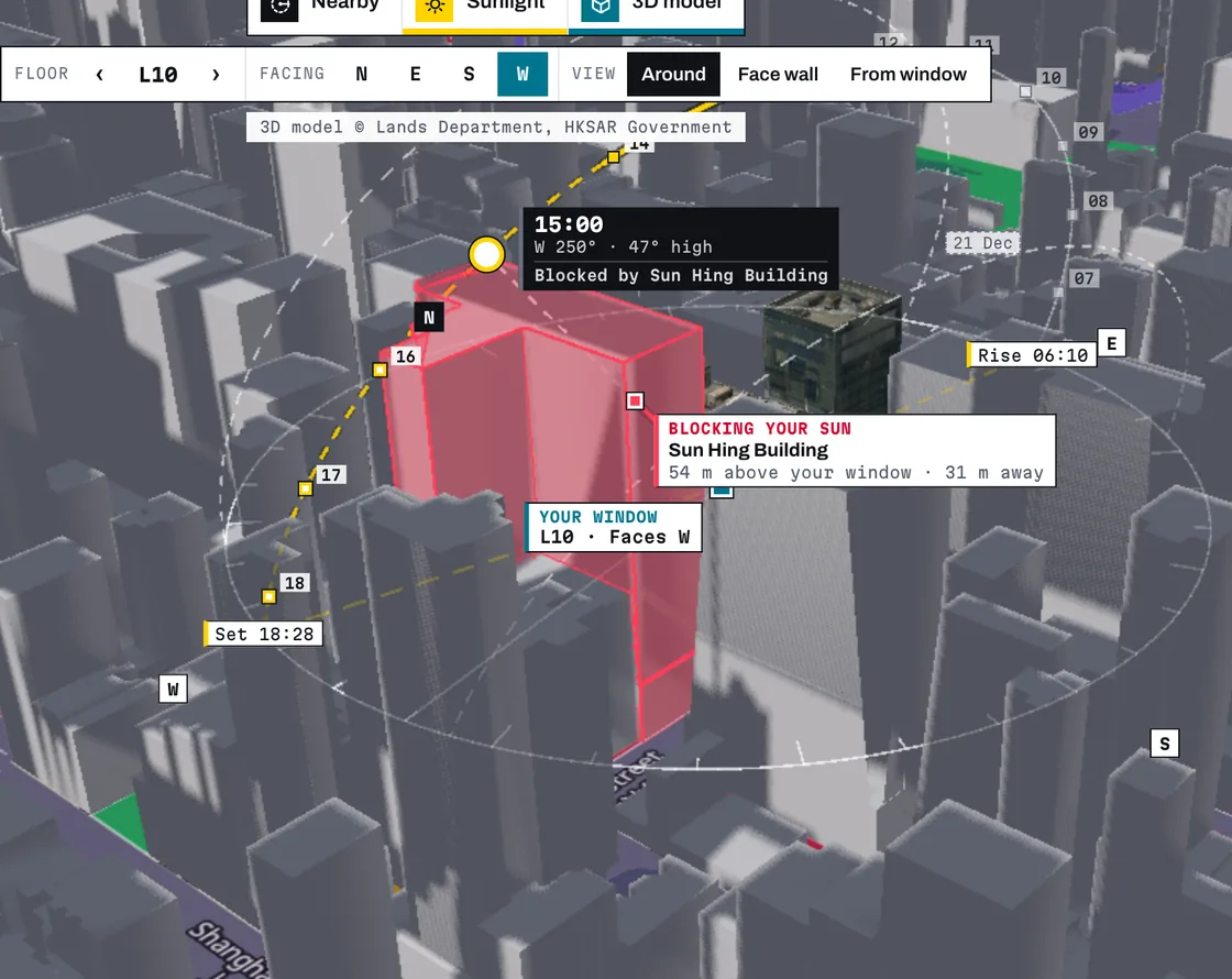
Around
The sun's path over the block, the shadows it throws, and the building that takes your light, in red.
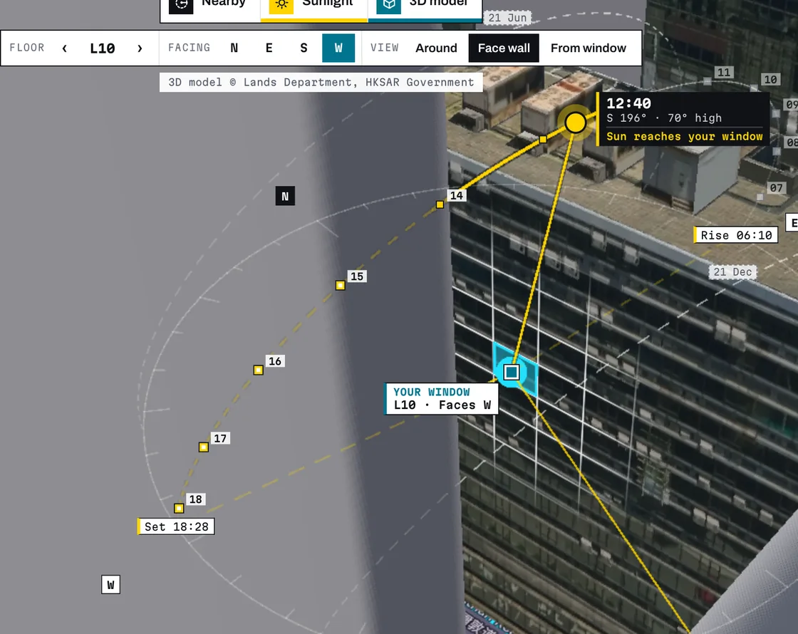
Face wall
Straight at the facade. Floors and 4 m bays are drawn on the government model, so you can point at the exact window.
From window
Sit where you would sit and look out at the skyline. Drag to turn your head, scrub the day and watch the sun cross it; whatever blocks the sun is named.
Recorded in the app · iSQUARE, Tsim Sha Tsui · south wall, 121 m up · 17 September, dawn to dusk


Nearby
What the government has on file, a street away.
Tap a building and the card lists what the government has on file at that address — orders, planning applications, restaurant and liquor licences, the owners' corporation, lifts. Nearby then measures what's around it: schools, clinics, new towers approved next door and the closest MTR exit.
- government datasets
- 57
- government datasets
- records on the map
- 250,579
- records on the map
- MTR exits, with their codes
- 629
- MTR exits, with their codes


3D model
The survey the government made of that building.
Not a satellite photo on a turntable: the Lands Department's textured 3D model, on real terrain, among the blocks around it. Floors are counted from the facade, so moving up the wall reads Level 1, Level 2, Level 3.
Open a model →Eight layers, one map
Tap any building, lot or zone and a card tells you what it is. No account, no pop-ups, no listings pushed at you.
Land-use zoning
11,953 zones from the statutory plans — residential, commercial, GIC, green belt, village
Buildings
342,249 footprints with height, storeys, floor area and year of completion
Building age
the whole city shaded by decade — 1950s tenement or 2020s tower, at a glance
Land lots
375,154 lots — the boundary the lease and the plot ratio actually follow
Statutory height limits
the ceiling in mPD or storeys, and how much headroom the building has left
School nets
all 36 primary nets, drawn down to the individual building
Who lives here
2021 Census for 1,746 neighbourhoods — household income, rent, renting, age
Aerial photo
the Lands Department's orthophoto under every layer — rooftops, open storage, trees
Hong Kong is the world's most vertical city — the flat two floors up has a different view, a different afternoon and a different price. Property portals give you a flat map and a photo. KongInsight gives you the building: its real shape and height, the rules written over it, and where the sun goes.
Built only on free Hong Kong government open data — Lands Department, Town Planning Board, Education Bureau, CSDI and data.gov.hk — with attribution on the map. We sell the analysis, never the raw data, and we don't take listings: nothing is on this map because somebody paid to put it there.
Free lookups · no account
Every HOS flat the Housing Authority has sold, floor by floor
63,592 Home Ownership Scheme and Green Form flats sold since 2019 — price, size and signing date for each one, and the discount each sale got. First-sale subsidised prices, not market prices.
Look up HOS prices →Siu Wu Court Block A · floors 32–39
HK$ million · darker = dearer per ft² within the block
On the top floor alone, the dearest flat costs 11% more per ft² than the cheapest.
More free lookups
Plans
Free while we launch
The complete map — every layer, the 3D models, sun & shadow, and every detail card. No account, no usage limit.
No paid plans today
Nothing to buy, nothing to cancel. If paid plans ever come, the pricing page says so first — and the free map stays free.
Government data, attributed
Every figure comes from Hong Kong open data — Lands Department, Town Planning Board, CSDI — with the source named on the map.
FAQ
Is KongInsight free?
Yes — the whole map, every layer, the 3D models, sun & shadow and every detail card, with no account and no usage limit. There are no paid plans on sale today; if that changes, the pricing page says so first.
What makes the 3D real?
The models are the Lands Department's own surveyed city mesh, streamed straight from government open data, on real terrain. The sun is the true solar position for Hong Kong at the date and time you pick — not a satellite photo on a turntable.
How accurate is the sunlight?
Direct sunlight only, from measured massing — clouds, glass and balconies are not modelled. Building shapes are accurate to about 4 m, so switch-off times can shift 5–10 minutes.
Where does the data come from?
Lands Department, Town Planning Board, Education Bureau, CSDI and data.gov.hk — all free open data, attributed on the map. Data © The Government of the HKSAR.
Do you list properties?
No. KongInsight is neutral property intelligence, not a listings portal, and no agent can pay to change what you see.
Languages?
繁體中文 · 简体中文 · English — all three, everywhere.
Can I share what I find?
Yes. Every view has a link, and whoever you send it to can open it without an account.